North Africa and Southwest Asia's Key Geographic Features
| Site: | Saylor Academy |
| Course: | GEOG101: World Regional Geography |
| Book: | North Africa and Southwest Asia's Key Geographic Features |
| Printed by: | Guest user |
| Date: | Tuesday, October 22, 2024, 12:34 AM |
Description
Read these two texts, which introduce this region's physical geography and cultural adaptations, and explain why this region is so arid. Notice that North Africa and Southwest Asia are home to the Fertile Crescent, which includes the Nile, Tigris, and Euphrates river valleys.
North Africa and Southwest Asia's Key Geographic Features
When geographers divide the world into regions, we often do so using landmasses. Have a big chunk of land might be mostly surrounded by water? Let's make it a region! Sometimes, though, making these sorts of divisions is more difficult. Africa, for instance, is almost entirely surrounded by water except for a small land connection with Asia at Egypt's Sinai Peninsula. But Sub-Saharan Africa is physiographically, culturally, and linguistically distinct from the African countries north of the Sahara.
In fact, North Africa has much more in common in terms of its physical and religious landscape with the Arabian Peninsula and Southwest Asia than some of its continental neighbors to the south (see Figure 7.1).
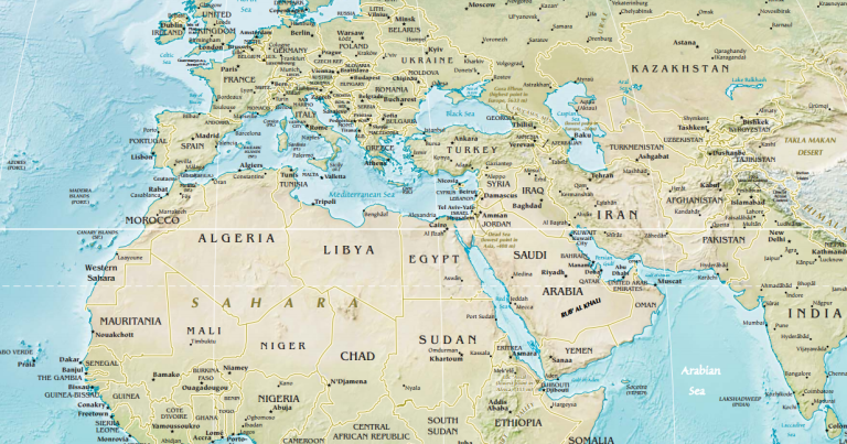
Figure 7.1: Map of North Africa and Southwest Asia (CIA World Factbook, Public Domain)
Historically, this perhaps awkwardly named region of North Africa and Southwest Asia was commonly called the "Middle East". This begs the question, though, what is it in the middle of? What is it east of? On a globe, east and west are relative terms. California is west of Europe but east of China. Indonesia is in Southeast Asia but is northwest of Australia. The equator might objectively be in the middle of the globe, but the "Middle East" is over 1,000 miles to its north. In truth, the term "Middle East" originated in Western Europe. Eastern Europe and Turkey were commonly referred to as the "Near East," while China was called the "Far East". The "Middle East" was thus in between these two regions.
Referring to the region as the "Middle East" seems to privilege the European perspective, so what alternatives exist? Perhaps you could call it the Islamic World? This would exclude places like Israel and secular governments like Turkey, as well as the numerous minority religious groups found in the region. You might have heard people refer to this area as the Arab World, but this would not apply to Iran, much of Israel, or Turkey. Thus we are left with simply the descriptive geographic name: North Africa and Southwest Asia, sometimes abbreviated as NASWA.
Whatever its name, this region is the hearth area for several of the world's great ancient civilizations and modern religions. The landscape of North Africa and Southwest Asia, as its naming difficulties imply, is marked by regional differences: in culture, in language, in religion, in resources, and in precipitation. Even within countries, regional
imbalances exist both in terms of the physical landscape and the patterns of human activity.
One of the most recognizable features of North Africa and Southwest Asia are its deserts. The Sahara, from the Arabic word ṣaḥrā‘ meaning "desert," is the largest hot desert in the world, stretching across 9.4 million square kilometers (3.6 million square miles) of the North African landscape. Although the typical image of the Sahara is its impressive sand dunes, most of the desert is actually rocky (see Figure 7.2).

Figure 7.2: Sahara, Algeria (© Cernavoda, Flickr, CC BY 2.0)
To the east, the Arabian Desert dominates the landscape of the Arabian Peninsula. In the southern portion of this desert is the Rub'al-Khali, the largest contiguous sand desert in the world. It is also one of the world's most oil-rich landscapes. There are also a number of highland areas across the region including the Atlas Mountains of Morocco, Algeria, and Tunisia and the Zagros Mountains of Iran, Iraq, and Turkey.
The prevailing climatic feature of North Africa and Southwest Asia is a lack of precipitation. From 10°to 30°north is a particular band of dry air that forms the region's hot desert climate zone (BWh in the Köppen climate classification system) and is clearly apparent on a map of global climate regions (see Figure 7.3). Most of the region receives less than 30 cm (12 in) of rain each year. This hot desert environment means that much of the land in the region is unsuitable for cultivation.

Figure 7.3: Map of Global Hot Desert (BWh) Climate Zones (© Peel, M. C., Finlayson, B. L., and McMahon, T. A., Wikimedia Commons, CC BY-SA 3.0)
There are exceptions to this arid environment, however. The region has a number of fertile river valleys and oases. The Nile River, for example, creates an arable floodplain in an otherwise extremely dry area (see Figure 7.4). While part of Iran is desert, northern Iran is actually home to dense rainforests and there are a number of scenic lakes. Coastal Turkey along the Mediterranean is often called the Turquoise Coast owing to its scenic blue waters. In general, however, those areas of North Africa and Southwest Asia where there is more abundant plant life are due to the presence of rivers, lakes, and seas rather than to the presence of ample rainfall.
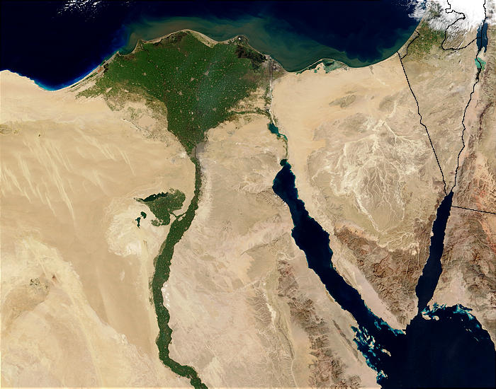
Figure 7.4: Nile River Delta from Space (© Jacques Descloitres, MODIS Rapid Response Team, NASA/GSFC, Public Domain)
In a realm largely defined by its arid and hot climate, global changes in climate could have profound effects. Climate and physical geography have already significantly constrained human settlement and development patterns in North Africa and Southwest Asia. Rising temperatures could exacerbate droughts, and heat waves and dust storms will likely become more frequent. In some areas, conflicts over limited water resources have already begun. The Nile River, for example, runs through ten different states and 40 percent of the entire population of Africa lives within its floodplain. Egypt consumes 99 percent of the Nile's water supply, though, putting pressure on other countries, like Sudan, to keep water flowing downstream. Much of Egypt's water demand is for the irrigation of cotton, but cotton actually requires a significant amount of water and is a nontraditional crop for such an arid environment.
Source: Caitlin Finlayson, https://pressbooks.pub/worldgeo/chapter/north-africa-and-southwest-asia/#chapter-263-section-1 This work is licensed under a Creative Commons Attribution-NonCommercial-ShareAlike 4.0 License.
Cultural Adaptations in North Africa and Southwest Asia
The climate and physical geography of North Africa and Southwest Asia have shaped population patterns and culture in the region. People in the region are generally clustered around the region's sparse water resources reflecting ancient patterns of human settlement (see Figure 7.5). Four regions in particular stand out as having high population densities: the Nile River valley, the coastal Mediterranean Sea, the Euphrates and Tigris river basins, and valleys of northwestern Iran.

Figure 7.5: Map of Population Density in North Africa and Southwest Asia (© Robert Simmon, NASA's Earth Observatory, based on data provided by the Socioeconomic Data and Applications Center (SEDAC), Columbia University, Public Domain)
Over 10,000 years ago, the earliest humans in North Africa and Southwest Asia settled in the Fertile Crescent, the area surrounding the Tigris, Euphrates, and Nile rivers (see Figure 7.6). Here, humans first domesticated crops and animals and created the first farming settlements. In Mesopotamia, in particular, the river valley of the Tigris and Euphrates, innovations occurred that would change the trajectory of human existence. This was where the wheel was first invented, the first system of mathematics was created, and the first cereal crops, such as barley and wheat, were planted. Mesopotamia was also the site of the first urban civilization, called Sumer. Uruk, a city of Sumer, had a population of over 50,000 people by 2500 BCE making it the most populous city in the world at the time. The ancient city of Babylon, located between the Tigris and Euphrates, was inhabited for thousands of years and was likely the first city to reach a population of 200,000.
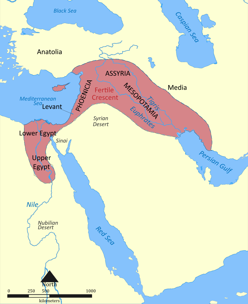
Figure 7.6: Map of the Fertile Crescent (© Nafsadh, Wikimedia Commons, CC BY-SA 4.0)
The people of this region have developed a number of adaptations to living in such a dry climate. Buildings are commonly designed with high roofs. Since hot air rises, having a higher ceiling allows the living area to remain relatively cool. Rooms are also often arranged around a common, shaded courtyard. This allows for maximum privacy, but also provides air flow throughout the living spaces. The traditional style of dress in parts of this region is also distinctive and reflects the physical landscape. Men might wear a cotton headdress to provide protection from the sand and sun as well as a long, flowing robe. Women's traditional clothing in the region is more reflective of religious values than environmental factors.
For some cultural groups in the region, adapting to the physical environment means migrating to cooler areas during the hottest parts of the year. The Berbers, for example, an indigenous group in North Africa, traditionally herd livestock and migrate seasonally seeking water, grazing land, and shelter. However, the way of life for many pastoral nomads in this region, like some Berbers, has changed significantly in recent years. Many governments have encouraged these groups to practice settled agriculture rather than seasonal migration, and international boundaries have often cut off traditional migratory paths.
The Persians, from modern-day Iran, devised an innovative way to transport water known as a qanat. Qanats are underground tunnels used to extract groundwater from below mountains and transport it downhill, where it is used to irrigate cropland (see Figure 7.7). They were developed over 2,500 years ago and many old qanats are still in use today in Iran as well as Afghanistan.
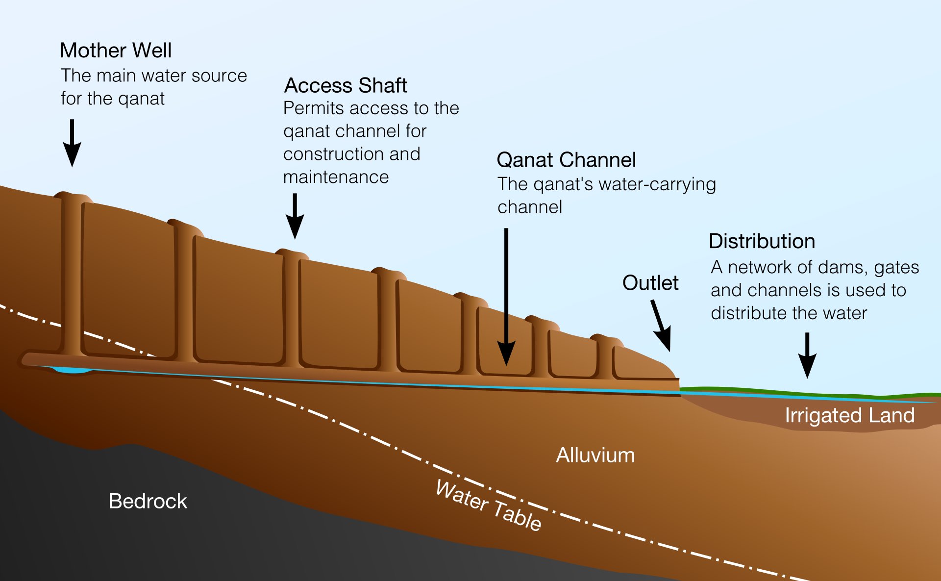
Figure 7.7: Cross-section of a Qanat (© Samuel Bailey, Wikimedia Commons, CC BY 3.0)
In such a harsh, arid environment, agricultural potential is fairly limited. River valleys and coastal areas provided small stretches of fertile land, but in the absence of widespread agricultural development, what other resources could bring this region wealth? In the early 20th century, oil was discovered in Saudi Arabia and this natural resource would prove both a blessing and a curse to the region.
Today, Saudi Arabia remains the world's leading oil exporter, shipping over 7.3 million barrels per day as of 2015. Kuwait, Iran, Iraq, and the United Arab Emirates are also among the top seven global oil exporters. Oil revenues have been able to increase development in these countries, financing industrialization, infrastructure, and providing high incomes. Qatar, for example, a small, former British protectorate on the coast of the Arabian Peninsula, has the highest GDP per capita in terms of purchasing power parity of any country in the world (as of 2018, according to the International Monetary Fund), at over $130,000 per person, largely due to its expansive oil and natural gas reserves. The tallest building in the world is now the Burj Khalifa, located in Dubai, United Arab Emirates. Although the United Arab Emirates, in building this 828 meter (2,717 feet) marvel, is seeking to diversify its economy and gain international recognition, its economy is still heavily dependent on oil.
Countries in the developing world with oil resources have often been prone to authoritarian rule, slow growth, corruption, and conflict. Oil wealth has been used to finance armies, and corrupt governments have pocketed oil revenue rather than reinvesting it in social programs or infrastructure. Furthermore, placing such a high emphasis on exporting one resource, like oil, has made this region vulnerable to changes in global energy demand. In 2015, countries in North Africa and Southwest Asia lost $390 billion in revenue due to low oil prices.
In an effort to coordinate oil production and prices, five countries including Venezuela, Iran, Iraq, Kuwait, and Saudi Arabia formed the Organization of the Petroleum Exporting Countries (OPEC) in 1960. Today, OPEC has 14 member states and covers over 40 percent of global oil exports (see Figure 7.8). OPEC cooperatively determines how much oil to produce and collectively bargains for the price of oil, rather than trying to compete to undercut one another. The United States and other countries have increased their own domestic oil production in recent years, causing OPEC's global share of oil exports to decline.
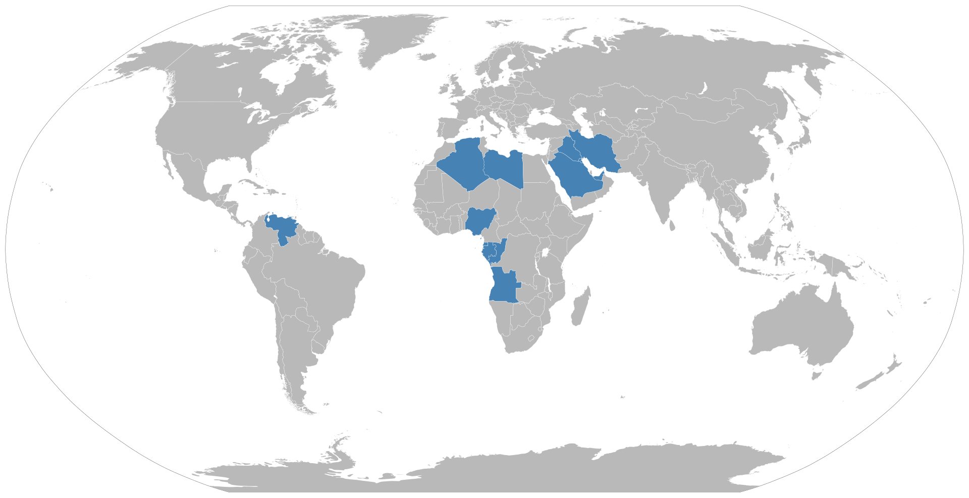
Figure 7.8: Map of OPEC Member States (Map by Bourgeois, Wikimedia Commons, Public Domain)
The presence of oil has also left a colonial legacy across North Africa and Southwest Asia, and has made these countries vulnerable to foreign control and influence. In addition, the uneven distribution of oil resources and wealth has led to inequality both within and between countries. Ethnic inequalities have also emerged as groups have uneven access to oil reserves and income. Oil has also changed the pattern of human settlement in the region by bringing in migrants from outside the realm attracted by the prospect of economic opportunity.